GIS Mapping & Data Services
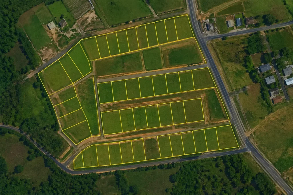
Land Parcel / Plot Mapping
Land Parcel Mapping involves identifying and mapping individual land plots with precise geographic boundaries. Using GIS technology and satellite imagery, we create detailed parcel maps that clearly show the shape, size, and location of land plots.
These maps are extremely useful for real estate development, land ownership identification, agricultural planning, and infrastructure development.
What We Do
- Identify and mark individual land parcels
- Create digital plot maps with accurate boundaries
- Integrate satellite imagery for reference
- Prepare maps suitable for land planning and documentation
Deliverables
- Parcel boundary GIS map
- Plot size and shape visualization
- Area measurement for each parcel
- GIS compatible files (Shapefile, KML, GeoJSON)
Benefits
- Clear understanding of land divisions
- Useful for property management
- Supports planning and land development
Deliverables
- Digital boundary map
- GIS boundary layer files
- Map layouts with coordinates and scale
- High-resolution map images for reports
Benefits
- Accurate land boundary identification
- Better planning for development projects
- Clear visualization of land limits
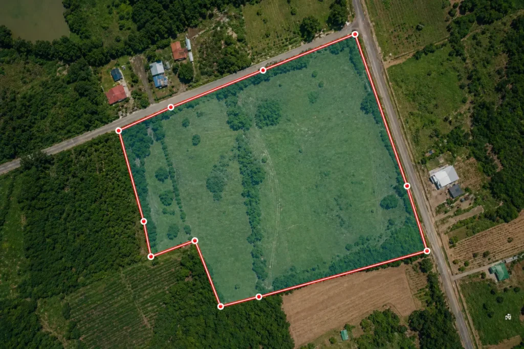
Boundary Mapping
Boundary Mapping focuses on defining the exact limits of a land area or project region. We digitize and create clear boundary maps based on satellite imagery, survey data, or provided coordinates.
This service is useful for land ownership verification, project site planning, environmental mapping, and legal documentation.
What We Do
- Digitize land boundaries from satellite images
- Map boundaries using survey or coordinate data
- Create clean and accurate GIS boundary layers
- Generate visual maps for reports or presentations
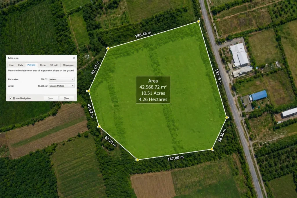
Area Calculation
Area Calculation helps determine the exact size of land parcels or project areas using GIS tools. We measure land area accurately using spatial data and provide results in multiple units.
This service is especially helpful for land valuation, agriculture planning, construction projects, and environmental analysis.
What We Do
- Calculate land area from GIS polygons
- Provide measurements in different units
- Integrate saVerify land size from satellite imagerytellite imagery for reference
- Generate area reports for documentation
Deliverables
- Area measurement report
- GIS map showing calculated area
- GIS data files for further analysis
Benefits
- Accurate land measurement
- Useful for land records and documentation
- Helps in planning and cost estimation
Deliverables
- High-quality map images (PNG / PDF)
- Printable map layouts
- Produce professional map layouts
Benefits
- Easy visualization of spatial data
- Professional maps for presentations
- Supports data-driven decision making
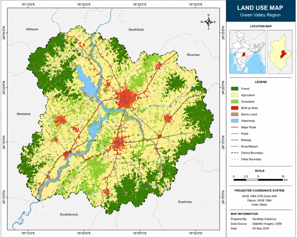
GIS Map Creation
GIS Map Creation involves designing professional maps that visually represent geographic data in a clear and informative way. We create maps that help users understand spatial information quickly.
These maps can be used for presentations, reports, research projects, government planning, and business analysis.
What We Do
- Digitize land boundaries from satellite images
- Map boundaries using survey or coordinate data
- Create clean and accurate GIS boundary layers
- Generate visual maps for reports or presentations
Map Digitization
Map Digitization is the process of converting paper maps, drawings, or scanned maps into digital GIS formats. This allows the data to be stored, analyzed, and updated easily.
Digitized maps can be used for urban planning, infrastructure mapping, research projects, and land management.
What We Do
- Convert paper maps into digital GIS layers
- Digitize features such as roads, rivers, plots, and buildings
- Georeference scanned maps to real-world coordinates
- Prepare structured GIS datasets
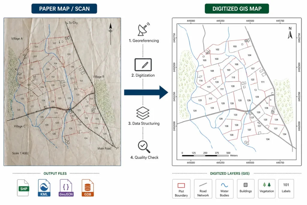
Deliverables
- Digitized GIS layers
- Georeferenced maps
- GIS file formats (Shapefile, GeoJSON, KML)
- Clean and structured spatial datasets
Benefits
- Easy data management
- Better analysis and visualization
- Long-term digital storage of maps